Nautical Chart

My nautical chart shows a make-believe coastal region. It has a pier which is the grey cross shaped that has black dividers so that boats don't bump against each other during large swells.
The island is on the top left of the Nautical Chart and is represented as a dotted-dashed line surrounded by colored lines to represent depth.
The legend shows everything that is on the map and very easy to understand because it is color coded. Enjoy!!!!
The island is on the top left of the Nautical Chart and is represented as a dotted-dashed line surrounded by colored lines to represent depth.
The legend shows everything that is on the map and very easy to understand because it is color coded. Enjoy!!!!
Latitude & Longitude
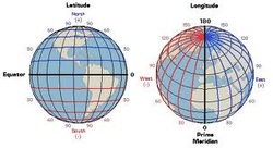
All nautical charts are based on a system of geographic coordinates. The best known and most widely used set of geographic coordinates are the Longitude & Latitude system. Latitude is a the set that includes circles that would lie on a plane surfaces cutting through earth. The Longitude system is base on circles that pass through the north and south poles.
The Mercator Projection is a familiar system of projections described as the Earths surfaces onto a cylinder wrapped so that the long axis of the cylinders shape is parallel to the Earths polar axis. This is useful for mapmakers and sailors because it depicts the three-dimensional curved surface of Earth on the two-dimensional flat surface of a paper chart.
The Mercator Projection is a familiar system of projections described as the Earths surfaces onto a cylinder wrapped so that the long axis of the cylinders shape is parallel to the Earths polar axis. This is useful for mapmakers and sailors because it depicts the three-dimensional curved surface of Earth on the two-dimensional flat surface of a paper chart.
Ocean & Coasts: Underwater Robots
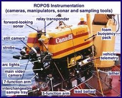
Modern ocean explorers use two main types of underwater robots: Remotely Operated Vehicles (ROV's) and Autonomous Underwater Vehicles (AUV's). ROV's are unoccupied robots linked by a group of cables to an operator aboard a ship, while AUV's are underwater robots that can operate without a pilot or cable to a ship or submersible. Underwater robots typically include some or all of the following systems: Power, Propulsion, Communication, Buoyancy Control, Navigation, Information Gathering (Environmental Sensors, Video, & Devices for Measuring Water Chemistry). In addition, some ROV's operate are equipped with other tools such as a Manipulator or Cutting Arm, Water Samplers, & Measuring Instruments to expand the vehicles capabilities. What i found interesting was that people are starting to be left up on board of the ship and beginning to send ROV's to collect data and samples in areas and at depths that would otherwise not be accessible by humans because of temperatures, depth, oceanic conditions, water pressure or lack of human capabilities.
Ocean & Coasts: Telepresence
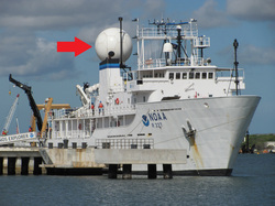
Telepresence is a group of technologies that allow people to observe and interact with events at a remote location. Aboard modern ocean exploration vessels, the foundation for telepresence is advanced broadband satellite communication. Telepresence capability allows live images to be transmitted from the seafloor to scientists ashore, classrooms, and newsrooms. This kind of interaction depends upon high-bandwidth satellite communications. "High Bandwidth" means that a large amount of data can be transmitted from the ship in a short amount of time, including high-definition video and real time voice communication. This technology is helpful because scientist all around the world can tune into the live video streams that the research vessels produce throughout their trips.
Ocean & Coasts: Multibeam Sonar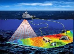
Sonar(SOund NAvigation & Ranging) systems are used to determine water depth, as well as to locate and identify underwater objects. It uses an acoustic signal or pulse of sound that is transmitted into the water by a sort of underwater speaker known as a transducer that when the sound bounces off the object and calculates the time elapsed to when it hits the transducer again. This object is often mounted on the hull of the ship or towed in a container called a towfish. In other instances a multibeam sonar is used, this uses multiple transducers pointing at different angles on either side of the ship to create a swath of signals. The muiltibeam sonar is a lot more useful because it creates three-dimensional models and 3D fly through models that can be looked at later during the trip.
|
Ocean Pathfinder:
|

Ocean & Coasts: CTD & Friends
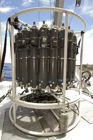
A CTD is a package of electronic devices that measure Conductivity, Temperature, and Depth. Conductivity is a measure of how well a solution conducts electricity and is directly related to salinity, and when combined with temperature data, salinity measurements can be used to determine seawater density. Each CTD is attached to a much larger frame called a rosette which holds the sampling vials that are closed at different depths to gather the samples for the scientists. Two other sensors that are often included on a CTD rosette are a light scattering sensor (LSS) used to measure the concentration of hydrothermal particles in the water & an Oxidation-reduction Potential (ORP)sensor that measures the tendency of a substance to gain or lose electrons. I find that it is really interesting because the CTD is a big contribution to the collection of data that otherwise would of been unknown to the scientists.
Oceans & Coasts : Aboard a Modern Ship Of Discovery
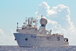
The Okeanos Explorer was commissioned on August 13, 2008 as Americas Ship For Ocean Exploration. It is the only U.S. ship whose main purpose is to routinely explore our largely unknown ocean for the purpose of discovery and the advancement of knowledge about the highly unknown ocean. Their strategy involves three major activities; underway reconnaissance, water column exploration, and site characterization. The also use a wide variety of CTD, Multibeam sonar, ROV, as well as Broadband satellite communication systems, these are just the few bits of technology that they use to explore the vast ocean.
Tools for Ocean Explorers
I feel that the Ocean Exploration is important for me because as a Surfer there is no limit to the amount of waves that could be surfed and with new found knowledge of the physical side of oceanography that can help us better understand the way waves work and how the conservation of coral reefs is important to us surfers.

Oceanographer
Bob Ballard is a visionary oceanographer who is continually extending our reach and understanding of the underwater world. Bob says that having a bachelors of science, a masters of science, and doctorate degrees would help you become an oceanographer. By learning more about the ocean we can get a greater understanding of the world around us, awareness of conservation issues, increasing our use of advanced technology. Also because you can excite and motivate young people to become life-long learners of science and technology. A senior oceanographer would make between $100,000 and $150,000 a year as full professors. I find that becoming an oceanographer would require a lot of hours and personal time but in the longterm the outcome of your research and your data will help us better understand how sensitive the ocean really is and help educate people from there on.

Coral Conservationist
The duties of a Coral Conservationist involves providing science support for our policy department, to ensure our proposed policy amendments are scientifically defensible. They also also work with Fishery Management Councils to attain protection for ecologically important ecosystems such as deep-sea coral reefs. In addition to the coral conservation role, provide guidance to our cruise line collaborators to ensure they serve only sustainable seafood. The research position, requires a need to have a PhD and the Marine Conservation Institute prefers their science positions to have a PhD, but a Master's degree plus relevant experience is also acceptable. A job this earns between $65,000-85,000 per year. The work on the southeastern U.S. deep coral reefs contributed directly to the establishment of a large coral protected area (~ 23,000 square miles) that will prevent the reefs from being damaged by fisheries and energy development. Good management preserves common resources for the benefit of the general public, rather than allowing them to be overexploited by a few. I have a strong admiration for the conservation of the oceans coral reefs because i am an experienced surfer that knows the importance of conserving the corals reefs because without the reef's, us surfers will start to experience the downfall of the depletion of coral reefs.
Marine Mammal Biologist
Generally the research is focused on the ecology of marine mammals. Studying the interactions between whales, seals and sea otters and their environment. Most of the time (about 9 months per year) is spent in a office writing papers or proposals, analyzing data, doing statistics, making models or preparing presentations. The other 3 months per year, they are in the field, where they go camping or live on a boat and observing, counting, catching or tagging marine mammals. People work in the field have a masters or Ph.D. But this is not necessary and plenty of people that study marine mammals hold B.S. degrees. But if you are the lead of a project, or in charge of a field team, you generally have some graduate work under your belt. I’d say someone holding a Ph.D. could make any where between 40,000 and 80,000 USD per year. They get to see some of the most amazing nature on the planet, work with extremely interesting animals, and travel to places with very fascinating cultural and people. I could see that the work benefits the public in that, the research conducted on the natural world enables managers to make effective decisions about conservation, and in some places, harvest of animals.
